Exploring the Log Cabin Mine, Mono County
#1
 10-22-2014, 12:13 PM

Exploring the Log Cabin Mine, Mono County
In the Eastern Sierra, near the little town of Lee Vining, there is an abandoned gold mine known as the Log Cabin Mine. I spent a day exploring around the mine. If you get a chance to visit the Mono Lake area, this is a good side trip.
To get there, take US 395 to CA 120 West. About a mile up CA 120 there will be a US Forest Ranger office on the south side, and across the road on the north side you will see a sign for the Log Cabin Mine, and for the Log Cabin Boy Scout Camp. The BSA has a high adventure camp right next to the mine site.
The road is a steep 2WD road as long as the conditions are dry. Some of it is rocky and might be hard on P-metric tires, but any high clearance vehicle with LT tires will make it fine.
Google Earth:
37� 58.738'N
119� 10.561'W
In the shot below you are looking down on the Ranger Station, Lee Vining Creek, and CA 120. You can see the turn-off to the mine.
Looking west from the same vantage, you can get an idea of how steeply the road climbs. The peaks around Yosemite are in the distance.


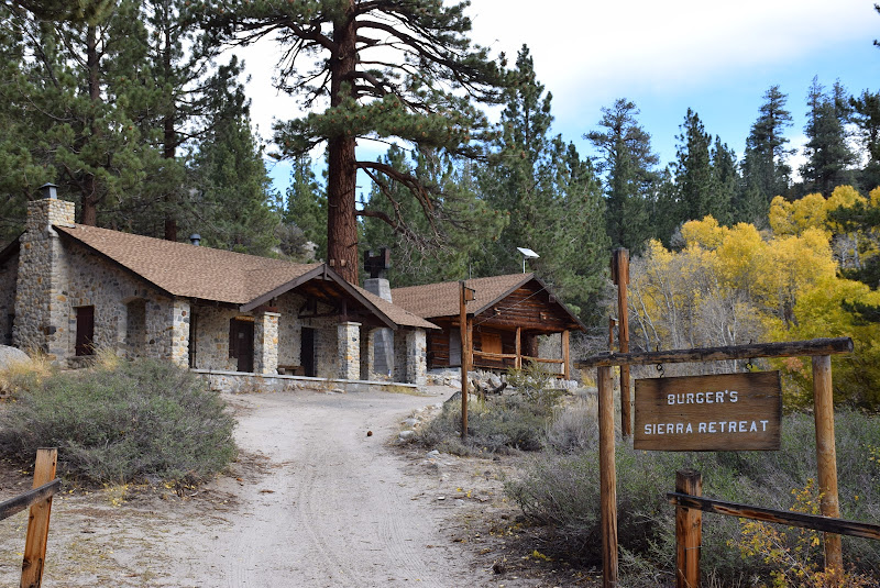
A short distance up the road you will enter a private property wildlife sanctuary, including this property known as Burgers Retreat. Nice spot to stop for lunch and maybe see some deer or other wildlife. The sanctuary stretches along 1.1 miles of the road.

Autumn is a good time to visit. The colors are spectacular.

Good views of Mono Lake. It looks like a little pond from here, but in fact Mono is a very large salt lake.


Be prepared for the elevation. It is up there.

When you get to the Boy Scout Camp, keep to the right. The road to the left circles around the BSC and goes far past the mine and gets very rough. Yes, I found the end. No, don't try it without 4WD. Take the road to the right and it is only a short distance to the mine entrance gate. Park here and walk about 100yds down to the mine mill site.

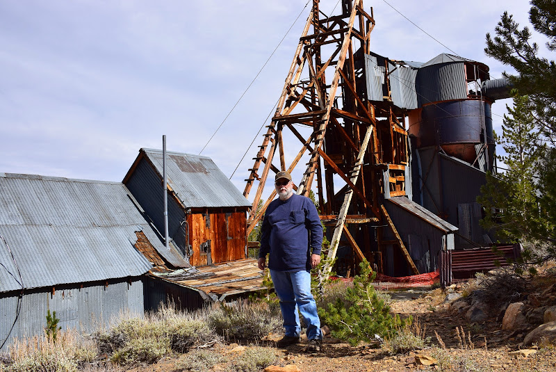
This will be your first view of the mine structures. Mill structure on the right, housing and feeding on left.

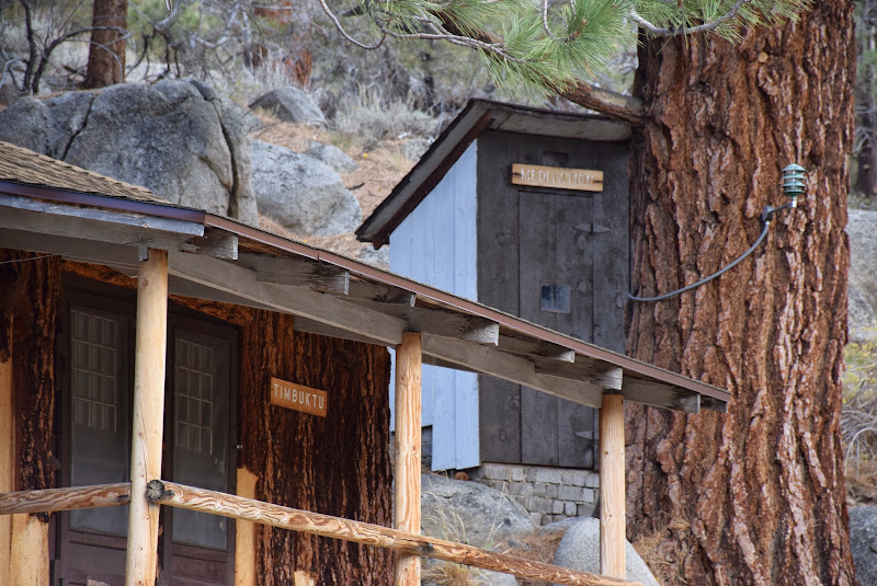
These are the barracks buildings.

I believe the nearest building was the mess hall. It was locked up and all windows were boarded up. The building in the rear was the kitchen, and a little cabin behind that was most recently used for food storage.

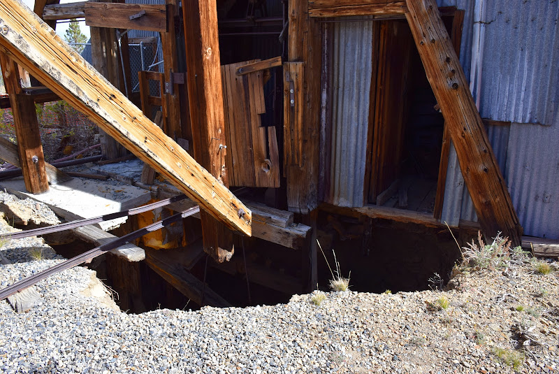
Below is a view of the business end of the mine. The closest building housed the winch equipment. Between that building and the mill building, under the derrick, is the vertical mine shaft.


These winches were used to move ore carts away from the shaft. My theory is that these were used before the long conveyors were added. The mining methods evolve over time, and I can see evidence of that around the site.


This is the vertical shaft. Be careful - it has not been filled or covered!

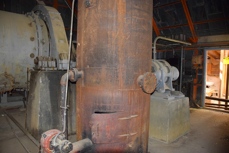
Steam was used at some point. All the electrical stuff appeared to be more recently added.

The back side of the mill building is in poor shape. It was extremely windy this day, and that is pretty common up here. Some of the siding that has not already fallen, was flapping around in the wind. Falling sheets of siding was one of my fears as I explored the site.

I have searched around trying to find where a horizontal tunnel emerged. This little dugout shack might have been it, but when I checked it out it looked more like an early root cellar kind of thing. I still have not found another shaft, but I think there has to be one.


The processing room, attached to the mill building. Seems to be a newer part of the site.

Behind the gray door below...
...is this processing equipment. Had to stick my camera through the windows to get the photo.
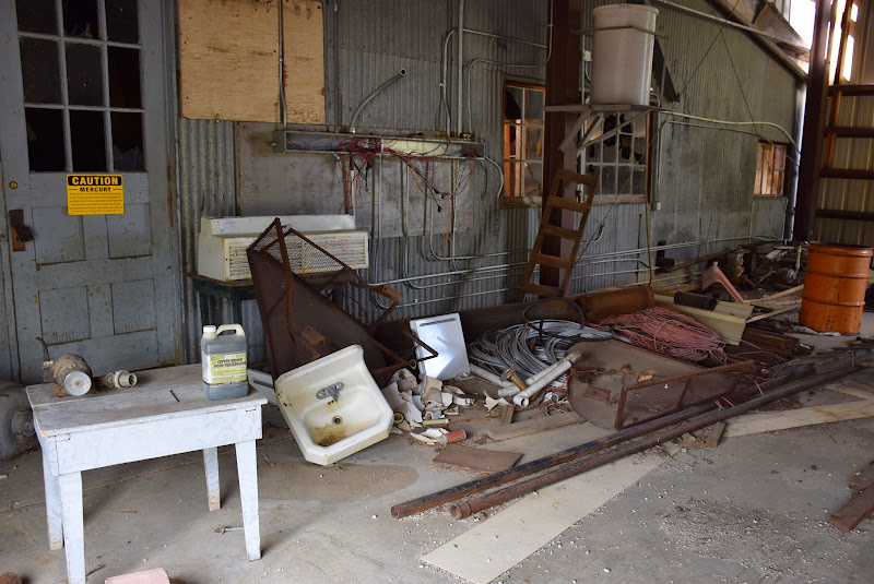
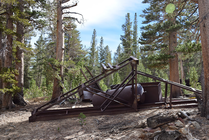
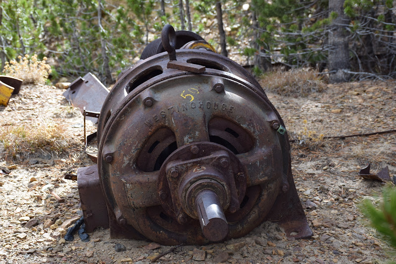
A lot of old interesting crap laying around.
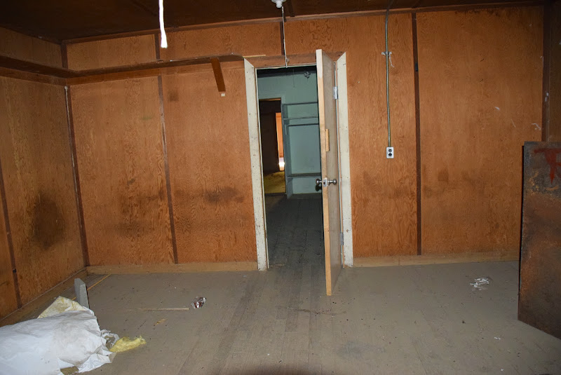
This is from inside one of the barracks buildings.


This is the food storage cabin that I mentioned before. Has a couple of walk-in refers and a screened pantry.

I thought the parking sign was funny. There was nothing behind it but a deep dry creek bed.


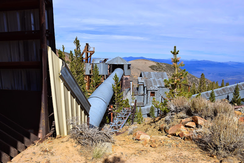
This is a newer portion of the site. These are grizzly bars, which separate large rocks from pay gravel. Gold bearing gravel and rock is dumped on these bars, and the smaller stuff falls through and is conveyed over to the older processing area. The larger stuff is either discarded, or maybe stamped and processed. Again, I think this is a later method of mining, and not related to the mine shaft. I see evidence of hard rock mining (the shaft), and placer mining (the grizzly separator and conveyors).

That "pipe" running over to the mill is actually a conveyor belt.

Back to the main mill building, this is the winch that raised and lowered the buckets down the vertical shaft.

The other side of the "root cellar" that I mentioned above. If this was ever a shaft entrance, I could not see it now.


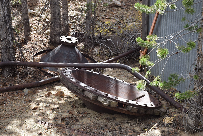
Lot of these laying around. I am surprised the copper thieves have not raided the place.
[img] [/img]
[img] [/img]
To get there, take US 395 to CA 120 West. About a mile up CA 120 there will be a US Forest Ranger office on the south side, and across the road on the north side you will see a sign for the Log Cabin Mine, and for the Log Cabin Boy Scout Camp. The BSA has a high adventure camp right next to the mine site.
The road is a steep 2WD road as long as the conditions are dry. Some of it is rocky and might be hard on P-metric tires, but any high clearance vehicle with LT tires will make it fine.
Google Earth:
37� 58.738'N
119� 10.561'W
In the shot below you are looking down on the Ranger Station, Lee Vining Creek, and CA 120. You can see the turn-off to the mine.
Looking west from the same vantage, you can get an idea of how steeply the road climbs. The peaks around Yosemite are in the distance.
A short distance up the road you will enter a private property wildlife sanctuary, including this property known as Burgers Retreat. Nice spot to stop for lunch and maybe see some deer or other wildlife. The sanctuary stretches along 1.1 miles of the road.
Autumn is a good time to visit. The colors are spectacular.
Good views of Mono Lake. It looks like a little pond from here, but in fact Mono is a very large salt lake.
Be prepared for the elevation. It is up there.
When you get to the Boy Scout Camp, keep to the right. The road to the left circles around the BSC and goes far past the mine and gets very rough. Yes, I found the end. No, don't try it without 4WD. Take the road to the right and it is only a short distance to the mine entrance gate. Park here and walk about 100yds down to the mine mill site.
This will be your first view of the mine structures. Mill structure on the right, housing and feeding on left.
These are the barracks buildings.
I believe the nearest building was the mess hall. It was locked up and all windows were boarded up. The building in the rear was the kitchen, and a little cabin behind that was most recently used for food storage.
Below is a view of the business end of the mine. The closest building housed the winch equipment. Between that building and the mill building, under the derrick, is the vertical mine shaft.
These winches were used to move ore carts away from the shaft. My theory is that these were used before the long conveyors were added. The mining methods evolve over time, and I can see evidence of that around the site.
This is the vertical shaft. Be careful - it has not been filled or covered!
Steam was used at some point. All the electrical stuff appeared to be more recently added.
The back side of the mill building is in poor shape. It was extremely windy this day, and that is pretty common up here. Some of the siding that has not already fallen, was flapping around in the wind. Falling sheets of siding was one of my fears as I explored the site.
I have searched around trying to find where a horizontal tunnel emerged. This little dugout shack might have been it, but when I checked it out it looked more like an early root cellar kind of thing. I still have not found another shaft, but I think there has to be one.
The processing room, attached to the mill building. Seems to be a newer part of the site.
Behind the gray door below...
...is this processing equipment. Had to stick my camera through the windows to get the photo.
A lot of old interesting crap laying around.
This is from inside one of the barracks buildings.
This is the food storage cabin that I mentioned before. Has a couple of walk-in refers and a screened pantry.
I thought the parking sign was funny. There was nothing behind it but a deep dry creek bed.
This is a newer portion of the site. These are grizzly bars, which separate large rocks from pay gravel. Gold bearing gravel and rock is dumped on these bars, and the smaller stuff falls through and is conveyed over to the older processing area. The larger stuff is either discarded, or maybe stamped and processed. Again, I think this is a later method of mining, and not related to the mine shaft. I see evidence of hard rock mining (the shaft), and placer mining (the grizzly separator and conveyors).
That "pipe" running over to the mill is actually a conveyor belt.
Back to the main mill building, this is the winch that raised and lowered the buckets down the vertical shaft.
The other side of the "root cellar" that I mentioned above. If this was ever a shaft entrance, I could not see it now.
Lot of these laying around. I am surprised the copper thieves have not raided the place.
[img] [/img]
[img] [/img]
#2
10-22-2014, 09:20 PM


Join Date: Oct 2010
Location: Northern and Southern Cal
Posts: 4,656
Likes: 0
Received 0 Likes
on
0 Posts

#4
10-22-2014, 11:10 PM
#5
10-22-2014, 11:44 PM

I love stuff like that. When I first moved to CA in '75, I squeezed past a gate on my trusty but silent XL 250 and took a couple long tours of an old coal mining area just south of Antioch. Summersville I think it was known as in the day. Almost got pinched on the way out, but the playing dumb act worked. (didn't have to play that hard to be honest....)
#6
10-23-2014, 03:47 AM
#7
10-23-2014, 08:42 AM
Thanks Sean. I think the remoteness of the site is a help. That's probably the only reason all that scrap metal has survived. Dopers won't have a way to get up there.
Didn't see a soul up there. The Scout camp runs a few weeks in the summer, and the road probably gets a lot of traffic during that time.
I had our trailer on Robinson Creek near Twin Lakes at Bridgeport.
Thought about it, but if you google you will find 2 or 3 other sites that have a lot of info, and those guys have more knowledge about the mining industry than I do. Some better photos of inside the buildings too. I was wondering where the stamp mill was located, but the other sites answered that question with photos of a ball mill inside the main building. I guess it is still there, but I could not safely get in there.
Thanks for the comments guys.
Trending Topics
#8
10-23-2014, 09:00 AM
One of the reasons they keep this road in pretty good condition, are these:


This mountain is directly above the town of Lee Vining, and gets a lot of snow. Those are avalanche cannons. Instead of the traditional Howitzer projectile cannon, these use propane gas to expel an explosive shock wave that will dislodge the snow safely. They have to deliver cylinders of gas to these before snow season each year.
I posted info on these back in our June 2010 chat thread.
#9
10-23-2014, 10:52 AM
Pop
#11
10-23-2014, 11:18 AM
Yep. The downside is that you need a road to service them. Not so with artillery. The upsides include, precise placement, no impact damage to the terrain, no unexploded ordinance laying around. Has to be less expensive long term.
#12
10-23-2014, 11:20 AM

#14
10-23-2014, 02:29 PM